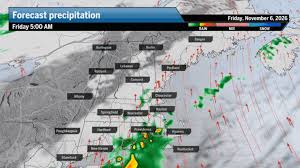
New England rain and flash flood forecast Friday, Digi Mart USA News (Boston, Massachusetts): After the longest dry stretch of 2026, Friday will bring two weather systems that unleash a slog of steady rain with isolated downpours across Boston, Southeastern Massachusetts and Rhode Island all day, before tapering off early Saturday morning.
Greater Boston and areas along Interstate 95 are expected to pick up a much-needed 1 to 3 inches of rain. Some areas could see more of a drenching, around a month’s worth of rain, as training cells packed with heavy rain push through the region.
Southeastern New England can expect a soaker of a day, from around sunrise through sundown, so forecasters advise bringing an umbrella. An advancing front is expected to stall over coastal New England, with scattered showers beginning by mid-morning across Greater Boston and much of the region.
Most of the rain will concentrate along that front, meaning there should be a sharp cutoff in rain intensity and rainfall totals west of Worcester and the Connecticut/Rhode Island border. Totals should also drop off considerably northwest of I-495.
Another round of rain arrives sometime Friday afternoon, when a low-pressure system works along that frontal boundary. This will bring more rain with occasional heavy downpours from Greater Boston to Rhode Island and across the South Shore and other coastal areas.
The flood risk on Friday has been elevated but should remain isolated. There may be a flash flood or two during the day for Greater Boston and areas to the south and southwest, so drivers are urged to allow plenty of time on the road.
A couple of localized rain totals could reach 4 to 5 inches by the time Saturday morning arrives.
A flood watch is in effect from Friday through early Saturday for Southeastern Massachusetts and Rhode Island. Scattered showers will trail the system early Saturday morning until dry air quickly settles in, and most areas should see dry conditions by the time people get moving for the day.
With the arrival of the rain, the 70-degree weather comes to an end. Friday holds an outside chance of reaching 70 degrees, which would break the existing four-day record tied on Thursday.
Saturday returns to a cool November day in the low 60s.
Greater Boston: Scattered showers to start, steady to heavy rain through the evening, with highs in the upper 60s. Central and Western Massachusetts: Scattered showers, mostly toward Worcester, with highs in the mid and upper 60s.
Southeastern Massachusetts: Scattered showers in the morning, turning to steady and heavy rain at times, with highs in the mid-60s. Cape Cod and the Islands: Scattered showers, heaviest near the bridges, with highs in the mid-60s.
Rhode Island: Scattered to steady rain at times throughout the day, with highs in the mid-to-upper 60s. New Hampshire: Mostly cloudy with scattered showers across the southern half of the state from late morning through most of the night, with highs in the 60s.
Vermont and Maine: Vermont is the least rainy state Friday, with some showers across the south and highs in the mid-60s. Maine sees showers to steady rain from late morning through the rest of the day, mainly along the coast, with highs in the mid and upper 60s.
Connecticut: Scattered showers to pockets of heavy rain, especially in the east, with highs in the upper 60s.