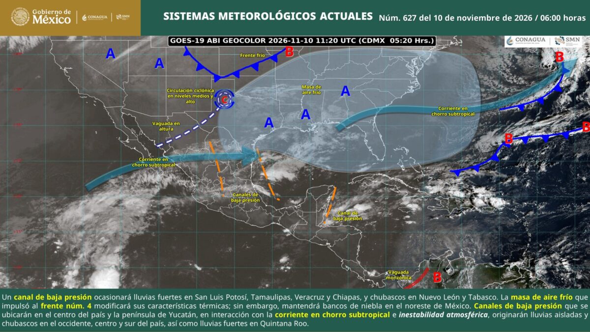
Mexico weather forecast heavy rain fog and frost November 10, Digi Mart USA News: Weather conditions on Tuesday, November 10, will be marked by significant rain in several regions of Mexico, mainly in San Luis Potosí, Tamaulipas, Veracruz, Chiapas and Quintana Roo, where precipitation of up to 50 millimeters is expected. Possible lightning, gusty winds and hail are also forecast.
According to the National Meteorological Service (SMN), a low-pressure trough over the western Gulf of Mexico will favor the heaviest rain in northern San Luis Potosí, northern and southern Tamaulipas, and northern, central and southern Veracruz. In Chiapas, precipitation will be concentrated mainly in the south, while in Quintana Roo it will affect the east of the state.
The agency said atmospheric instability will also develop in the central part of the country and the Yucatán Peninsula, due to the interaction of low-pressure troughs with the subtropical jet stream. This scenario will bring intermittent showers to Nuevo León, Jalisco, Michoacán, Guanajuato, Querétaro, Hidalgo, Puebla, State of Mexico, Guerrero, Oaxaca, Tabasco, Campeche and Yucatán.
Isolated rain is also forecast for Baja California Sur, Chihuahua, Coahuila, Zacatecas, Aguascalientes, Colima, Mexico City, Morelos and Tlaxcala.
The SMN warned that heavy rain could cause rising river and stream levels, landslides, waterlogging and flooding, mainly in low-lying and vulnerable areas. Storms may bring lightning, hail and wind gusts strong enough to bring down trees, light structures and billboards.
Another risk factor will be fog banks in the northeast of the country, as the cold air mass that drove cold front number 4 begins to change its thermal characteristics but still retains conditions favorable for fog. Reduced visibility could affect vehicle traffic on highways and urban roads, and drivers are advised to exercise extreme caution.
Despite the rain, maximum temperatures will reach between 35 and 40 degrees Celsius in southern Sonora, Sinaloa, Nayarit, Jalisco, Colima, Michoacán, Guerrero, Oaxaca, Chiapas and Campeche. Values of 30 to 35 degrees are expected in Baja California Sur, southwestern Puebla, southern Morelos, central and southern Veracruz, Tabasco, Yucatán and Quintana Roo.
In contrast, cold conditions will continue during the early hours of the day in mountainous areas of northern and central Mexico. Chihuahua and Durango will record minimum temperatures between -5 and zero degrees Celsius, with possible frost, while mountainous regions of Baja California, Sonora, State of Mexico, Tlaxcala, Puebla and Oaxaca are expected to see values of zero to five degrees.
Regarding wind conditions, Tamaulipas will have speeds of 20 to 30 kilometers per hour, with gusts of 40 to 60 kilometers per hour. Northerly winds are also forecast across the Isthmus and Gulf of Tehuantepec in Oaxaca and Chiapas.
In other states, gusts could reach 30 to 50 kilometers per hour.
Wave heights of two to three meters are expected on the western coast of the Baja California Peninsula, while in the Gulf of Tehuantepec they could reach one to two meters. The SMN said it is monitoring the possible effects of a new cold air mass entering the Gulf of Mexico, which could change weather conditions in the coming days.
Given this outlook, the agency recommended staying alert to official warnings, avoiding crossing swollen rivers or streams, securing objects that could be moved by the wind, and driving carefully in areas with fog or heavy rain.