New Jersey coastal storm chilly rain gusty winds colder temperatures, Digi Mart USA News (New Jersey): New Jersey weather will shift from warm, dry and pleasant to chilly, wet and windy within about 24 hours, as a storm system moving in from the central U.S. and colder air seeping in from Canada take hold.
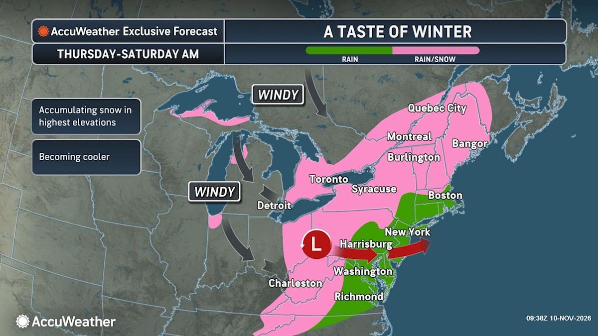
The system is expected to arrive Thursday and transform into a coastal storm that strengthens as it drifts off the Jersey Shore on Friday. Most areas of northern New Jersey will likely receive an inch of rain or slightly more, while only a quarter-inch to a half-inch is expected across the southern half of the state.
As the storm strengthens late Friday and temperatures drop into the 30s, some snow could mix in with the rain in northwestern New Jersey, according to forecasters from AccuWeather and the National Weather Service. A slushy coating of snow could accumulate in the Poconos region of northern Pennsylvania, while 1 to 3 inches may accumulate in parts of the Hudson Valley in New York, just north of northern New Jersey, AccuWeather said.
The nasty weather will arrive one day after New Jersey enjoyed a calm, sunny and warm Wednesday, with afternoon highs reaching the mid- to upper 60s. Rain is expected to spread from west to east across the state during the morning and afternoon hours Thursday, with the heaviest rainfall focused across northern and central portions of the state.
Forecasters say a rumble of thunder is possible along the coastal plain late Thursday night and Friday morning as the storm strengthens just offshore. Some elevated locations across northwestern New Jersey may see a few wet flakes mixing in with the rain, but no snow accumulations are expected there.
There is uncertainty about how much total precipitation will fall, as forecasters note that a more northward track of the storm center would result in less rainfall across the region. Minor tidal flooding is possible along the coast during high tide cycles on Thursday and Friday, the National Weather Service said.
Winds will increase Thursday night into Friday as the storm intensifies offshore, with northwest wind gusts of 20 to 25 mph expected Friday. A sharp drop in temperatures follows the storm on Friday, with daytime highs failing to climb out of the 40s for much of the state.
Overnight lows Friday night into Saturday are forecast to fall into the 20s to low 30s, and the first freeze of the season is likely for parts of southern New Jersey where the growing season is still active. Saturday will be breezy to windy, with peak gusts reaching about 35 mph out of the northwest and high temperatures remaining in the 40s.
Sunday will still be gusty with somewhat lower wind speeds, and temperatures will begin to moderate slightly. High temperatures Sunday through Tuesday are expected to reach only the upper 40s to low 50s, which remains below average for mid-November.
Dry weather is expected to return for most of the weekend and continue into the middle of next week as high pressure builds into the region.