Mexico weather forecast rain and temperature drop November 9, Digi Mart USA News (Mexico): Weather conditions for Monday, November 9 will keep much of the national territory under various climate scenarios, with rains that could cause flooding, landslides and river rises, as well as low temperatures in the mountainous regions of the north and center of the country.
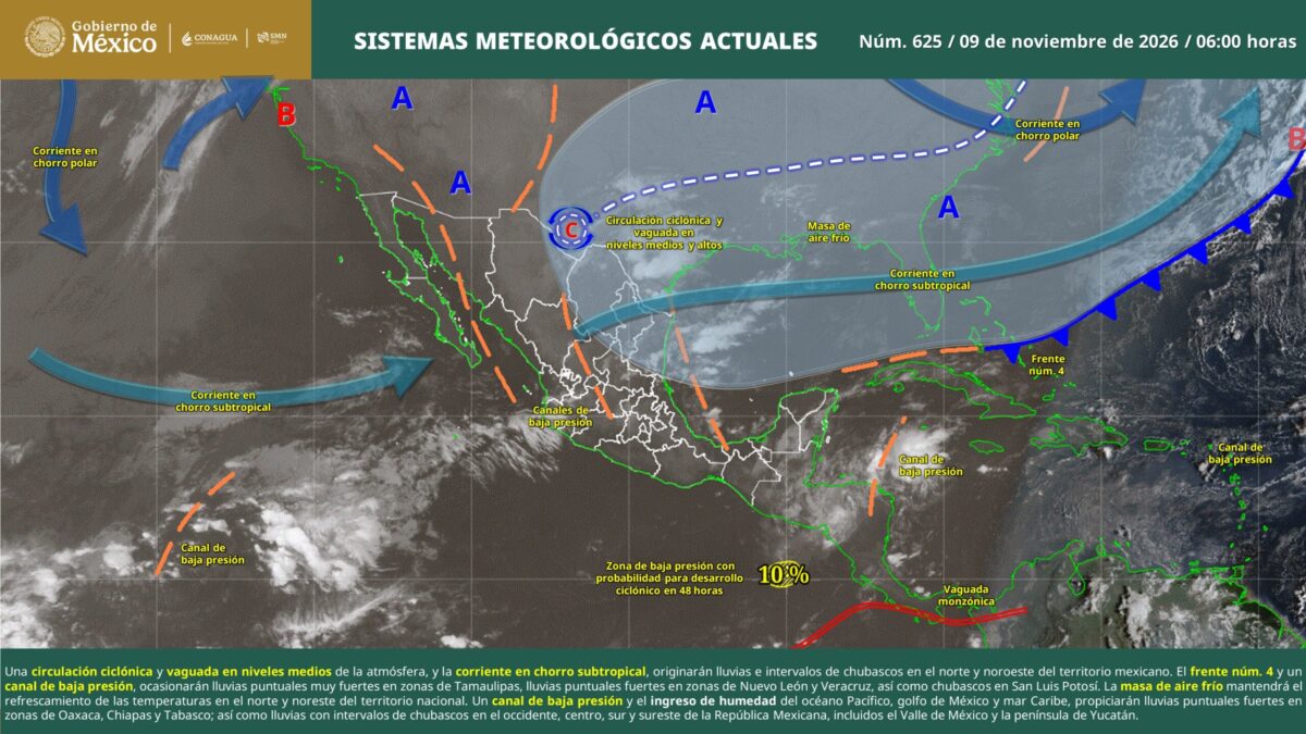
According to the National Meteorological Service (SMN), the cold front number 4 remaining over eastern Mexico, combined with a low-pressure trough in the northeast, will favor significant precipitation, mainly in Tamaulipas, where very heavy localized rains of 50 to 75 millimeters are forecast.
Strong rains of 25 to 50 millimeters are also expected in parts of Nuevo León, Veracruz, Puebla, Oaxaca, Chiapas and Tabasco. These conditions will be accompanied by electrical activity, possible hail and gusts of wind, and authorities recommend extreme caution.
The weather service warned that the precipitation could raise the levels of rivers and streams, cause landslides, waterlogging and flooding, particularly in low-lying areas and vulnerable localities. Gusts of wind could also bring down trees, branches and billboards, while fog banks would considerably reduce visibility on highways and in urban areas.
In the north and northwest of the country, a cyclonic circulation, a mid-level atmospheric trough and the subtropical jet stream will favor rain and showers in various states. Showers are expected at intervals in Baja California, Baja California Sur, Chihuahua, Durango, Coahuila and San Luis Potosí, as well as Guanajuato, Jalisco, Michoacán, Querétaro, Hidalgo, State of Mexico, Morelos, Guerrero and the states of the Yucatán Peninsula.
Mexico City, Sonora, Sinaloa, Zacatecas, Aguascalientes, Colima and Tlaxcala will record isolated rainfall.
While the cold front will bring a cooler environment to the north and northeast, maximum temperatures will remain high in states in the west and south. The forecast includes values of 35 to 40 degrees Celsius in southern Sonora and Sinaloa, as well as San Luis Potosí, Nayarit, Jalisco, Colima, Michoacán, Guerrero, Oaxaca, Chiapas and Morelos.
Baja California Sur, Puebla, Tabasco, Campeche, Yucatán and Quintana Roo could reach temperatures of 30 to 35 degrees.
In contrast, the mountain zones of Chihuahua and Durango will face minimum temperatures of -5 to 0 degrees Celsius. Readings of 0 to 5 degrees are also expected in mountainous regions of Baja California, Sonora, Zacatecas, Hidalgo, State of Mexico, Tlaxcala, Puebla, Veracruz and Oaxaca.
Atmospheric conditions will also produce north-component winds of 20 to 30 kilometers per hour, with gusts of 40 to 60 kilometers per hour on the coasts of Tamaulipas and the Isthmus and Gulf of Tehuantepec in Oaxaca and Chiapas. Gusts of 30 to 50 kilometers per hour are forecast in other regions, particularly in the north, center and southeast.
Regarding swells, waves of two to three meters are forecast on the western coast of the Baja California Peninsula, while in Tamaulipas and the Gulf of Tehuantepec they could reach one to two meters.
The SMN continues to monitor the effects of cold front number 4 in eastern national territory and of an upper-level trough over the northwest, and urged the public to stay informed through official alerts and follow recommendations from Civil Protection.
Authorities advise avoiding crossing water currents, securing objects that could be displaced by wind, and exercising extreme caution when driving in the presence of rain and fog banks.